Cartographic collection of Poznań University Library dates back to the very first years of the library known then as Kaiser Wilhem Bibliothek. 19th c. topographic maps of Prussia and other German lands come from the time. After the creation of Poznań University in 1919, a decision to Polonize the collection ensued. At the outbreak of W.W.II the collection already consisted of 5,800 maps and 52 atlases. The years 1945-1949 were crucial in obtaining additional valuable cartographic material as the result of the action of reassembling and protecting of the abandoned and dispersed bookstock.
A few years later an independent map room was formed within the structure of the Special Collection Department.
Chronological range of the collection is wide and encompasses items from as early as the 15th c. Among the most valuable material the following are worth mentioning:
Handwritten (manuscripial) map of the world included in the collective codex by Jakub z Kowalewic written in 1478,
Map of Poland from Itinerarium Orbis Christiani published in 1579/80 – the only copy in Polish cartographic collections,
Celestial globe made by Gerard Mercator in 1551,
Several editions of Ptolemy’s Geography, including one edition from 1541,
First edition of Mercator’s atlas of the world (1595), a map of Central Europe by A. Salamanca.
Map room also has numerous editions of Ortelius’s, Mercator’s Janssonius’s, and Homann’s atlases. There is also a worthwhile collection of Polish maps and maps relating to Poland from the 16th and 17th c. The collection also includes valuable cartographic material pertaining to the history of Poznań and the region.
Map room has a rich collection of reference books, especially in the history of cartography. There are plentiful catalogues as regards the maps and atlases in possession of the Section.
Bibliography:
Puckalanka U., Zbiory kartograficzne BUAM w Poznaniu. Zeszyty Naukowe UAM, Biblioteka 2, (1962)
Puckalanka U., Mapy Polski z XVI wieku w zbiorach BUAM. ZNUAM, Biblioteka 3
Puckalanka U., Nieznana mapka świata w polskim rękopisie z XV wieku. W: Studia i materiały z Dziejów Nauki Polskiej. Seria C. Z.13. (1968)
Zbiory kartograficzne w PRL. Warszawa 1972
Ze skarbów bibliotek wielkopolskich. Warszawa-Poznań 1980
Michałowski R., Mapa Polski XVI – XVIII w. (Katalog wystawy). Szamotuły 1996;
Michałowski R., Puckalanka U., Zbiory kartograficzne. W: Prace polonijne BU w Poznaniu. Warszawa 1995
map1_d
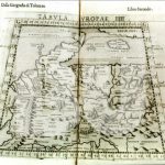
"Tabula Moderna Sarmatie... Polonie..." w: "Ptolemaeus Auctus Restitutus..." Argentorati 1520
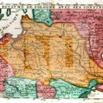
"Etats de Pologne..." M. Brion, L. Desnos Paryż 1772
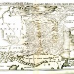
"Le Royavme de Pologne..." N, de Fer Paryż (?) k. XVII w.
"Karte von Polen...in XVI Blăttern..." D.F.Sotzmann Berlin 1795. (fragment kartusza)
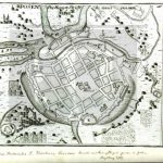
"Posen - Poznań (Plan miasta)" G.Bodenehra w "Theatrum Curioses..."
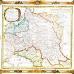
"Kreis - Karten der Provinz Posen." Arn. Poznań Glogav [przed 1858] Carl Fleming Verlag
We use cookies on our website to give you the most relevant experience by remembering your preferences and repeat visits. By clicking “Accept All”, you consent to the use of ALL the cookies. However, you may visit "Cookie Settings" to provide a controlled consent.
This website uses cookies to improve your experience while you navigate through the website. Out of these, the cookies that are categorized as necessary are stored on your browser as they are essential for the working of basic functionalities of the website. We also use third-party cookies that help us analyze and understand how you use this website. These cookies will be stored in your browser only with your consent. You also have the option to opt-out of these cookies. But opting out of some of these cookies may affect your browsing experience.

!["Kreis - Karten der Provinz Posen." Arn. Poznań Glogav [przed 1858] Carl Fleming Verlag](https://lib.amu.edu.pl/wp-content/uploads/2018/05/map7_d-150x150.jpg)